I Got Lost In The Mountains Link to heading
I was out riding my motorcycle in the Santa Cruz mountains recently and got lost. This wasn’t really a problem, I was out for the journey and didn’t really care where I was; though what I did want was some sense of direction. I opened Google Maps and tried directing it towards some interesting roads. It didn’t like that, Google Maps is built to get you where you’re going efficiently and quickly, not interestingly. After several minutes of fussing while on the side of the road, I dropped a pin forcing the general direction I wanted to go, thinking it would also take me in the general direction of home. This was a great idea in theory, but as I would quickly learn in practice, it was actually terrible for me.
Along the way I took a wrong turn and Google Maps’ GPS quietly failed into silence. I didn’t notice, as will happen when you’re on a motorcycle, and just kept riding, expecting to eventually hear directions or hit a familiar road towards home. I ended up even further away from home, reaching the coast. What. I didn’t expect to see the ocean, I thought I was driving inland. The coast is pretty, but I need to go home and I’m already tired. I look at Google Maps again, home is a 2 hour ride away. That’s not good, but I don’t have a lot of other choices, I have to get home.
When I finally got home I was exhausted. I pulled into the driveway and maneuvered toward my parking spot. Unfortunately my leg strength was long gone and I dropped my motorcycle in the process of parking it, straight onto the pavement–a rider’s nightmare. Fortunately the only injury was to my pride, but as I stood over my fallen steed, it became immediately clear that my long, unplanned ride had pushed me too far. This wasn’t the first time a ride was too long, but it was the first time it’d been so obvious and came with a cost to drive the point home; next time it might be a bad decision on the road with a much bigger cost. I realized I needed a way to plan and visualize a ride before I ever left home.
The Idea Link to heading
I stewed on the idea for a couple of days and came to the assumption that I could accomplish a ride plan easily in one of the popular apps; this would be the path of least resistance. I started researching and came to the conclusion that it was not as easy as I thought, as Google Maps only supports a handful of points in a route, Waze only accepts point-to-point destination planning, the list of apps and limitations goes on. No standard GPS app gave me the visualization and routing I wanted. I looked at the motorcycle-oriented GPS apps and was similarly dissatisfied with the results; they didn’t support my idea or if they did, it was very kludgy. On top of this, all of these GPS apps veered hard into optimizing your trip, either by making it faster or shorter, not interesting. I want to ride on interesting roads, not Hwy 280 for the 7,000th time. As an experienced product manager in tech, I decided to see if I could build what I wanted with just AI. I’ve built products with teams of engineers, how hard could it be?
First Draft Link to heading
When I started, the tool didn’t even have a name, it was simply ‘route builder.’ My thinking was that I’d knock out a simple Google Maps wrapper with the planning and visualization I wanted and stop there. I was excited, my idea seemed to work for my need, then I started really poking at its feasibility and found limitations pretty much everywhere–Google didn’t like my use-case and tamped down the routes to a handful of points, causing anything longer than a few miles to break instantly. I realized that Google wasn’t going to be my solution after all, so I looked into alternatives. After some experimentation I landed on Stadia Maps, whose API agreed with and supported my use-cases. Complex routes are back on the menu!
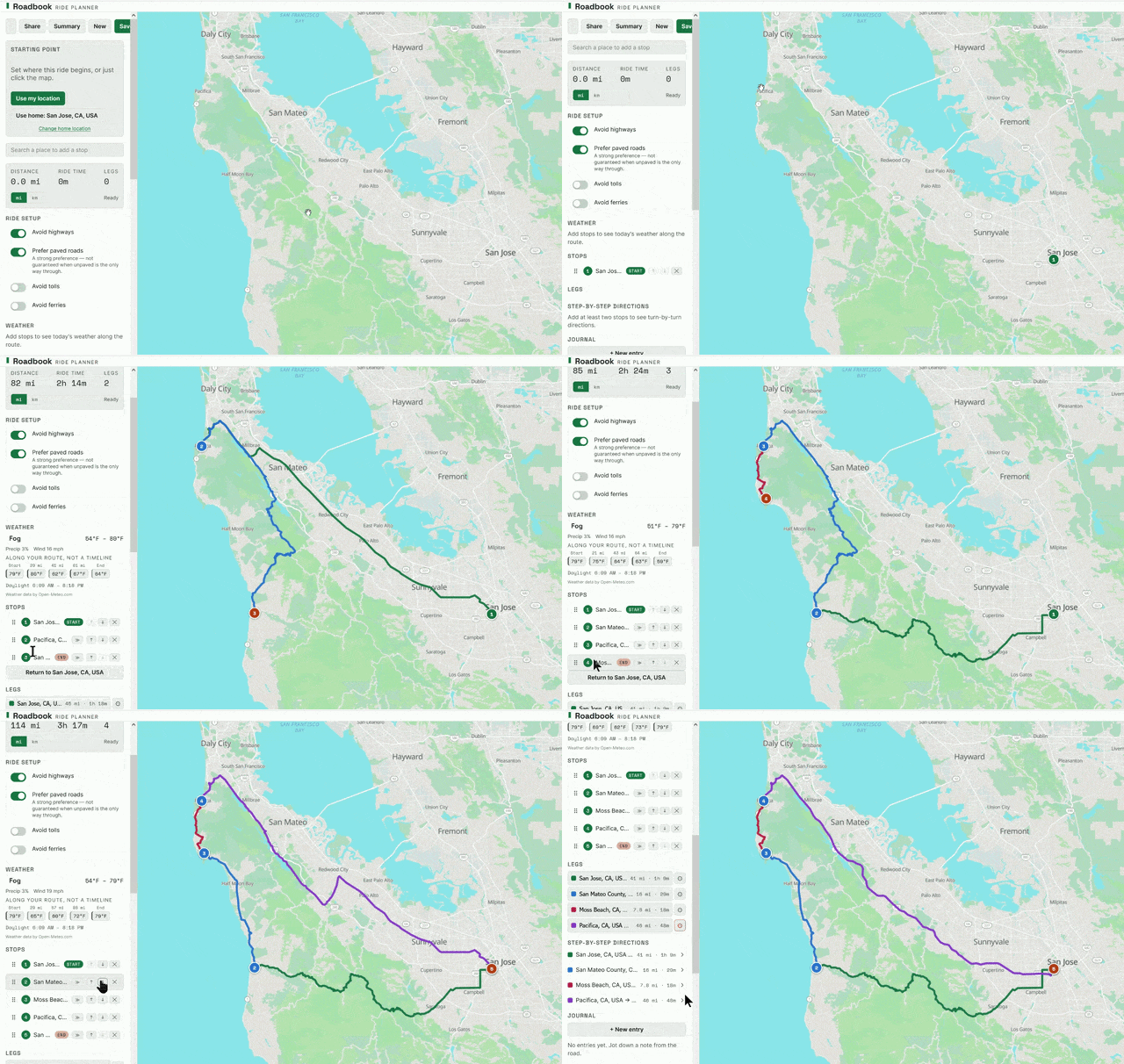
With the Stadia API I could now fully plan out and build the tool. I worked with Claude to create a PRD (Product Requirements Document) detailing how I wanted the tool to function, with such guidelines as “this is a pleasure riding app, not a ‘get there fast’ app,” maintaining the direction of ‘interesting rides’ over getting to your destination quickly. Then I fed the PRD back to Claude for implementation, answering questions and making adjustments as I went. Out came version 1, a map I could do basic planning and visualization against. This is what I wanted to begin with! Within a week I iterated it into a tool that could produce maps with road preferences, stops, and weather. Now I could have a real understanding of what a ride would look like before I ever got on the bike. The tool got a proper name, Roadbook. I thought that I was done with development.
This Is Great, But Link to heading
I had accomplished my original goal of visualization and planning, fantastic! Now it was just a matter of using the planned routes, which I found out was easier said than done: Google Maps, Waze, and others intentionally ingest only very basic data through their APIs, so you can’t send a route to Google and expect to be able to follow it–those same limitations from before. What if I were to create a GPX (GPS data) file with all the information? As I quickly learned, very few apps support GPX ingest and those that do want money for the privilege. With that, it seemed I was out of options for actually following the route while on the motorcycle–no GPS did what I wanted. The next natural step? Clearly it’s: “Fine, I’ll do it myself.”
Scope Creep Is Real Link to heading
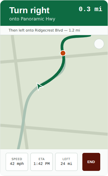
Building my own GPS would also be the transition point where the desktop app became more than a desktop app: my route builder could now do a lot more than just visualization on your home computer–it could actually take you on that planned route on your phone. This new goal was way outside of what I’d originally planned to do, but it seemed feasible. It certainly helped that I was already using the Stadia Maps API, which gave me everything I needed. So I sat down with Claude and wrote a new document detailing build-out of the GPS and its functionality. Again Claude produced a ready-to-go app to iterate upon. GPS is go!
Who Are My Users? Link to heading
Up to this point I’d considered myself as the only user of this planning tool, because who wants to use a desktop-locked app to plan a route that they can’t follow? Building the GPS made me reconsider myself as the only user: my friends would probably enjoy it for their rides as well. I shared it with a handful of riders and they wanted to share with others. Suddenly my tool was being used by more than just myself. It made me ask who else shares my use-case and wants a motorcycle-focused GPS–how big might the audience be? I started considering what it might take to scale my unpolished single-user tool into an app that any rider could use. I mean, how hard could it be?
I’ll talk about that journey in the next post. In the meantime, have a great one (and if you’re a rider, try out Roadbook!)